The mining industry, a fundamental pillar of modern civilization, has a long and intertwined history with the evolution of mining surveying techniques. From the rudimentary tools and manual measurements of early mining operations to the sophisticated technologies employed today, accurate surveying has been indispensable to successful resource extraction.
This article delves into this rich legacy of precision, focusing on the transformative impact of manned aircraft aerial surveying, incorporating state-of-the-art technologies such as airborne light detection and ranging (LiDAR) and aerial photogrammetry, on the modern mining and mine surveying landscape. While some industries explore unmanned aerial vehicle options, and others leverage satellite imagery, this article focuses on the advantages and applications of manned aircraft for detailed and precise surveying in mining.
From Plumb Bob to Point Cloud: A Journey Through Mining Surveying History
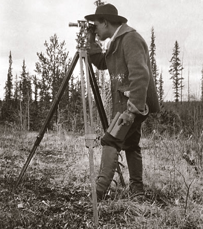
The earliest mining endeavors relied on fundamental surveying instruments like the compass, chain, and plumb bob. These instruments, while seemingly simple, were essential for establishing property boundaries, delineating tunnel routes, and estimating ore bodies. As mining operations expanded, so did the demands on surveying in mines.
The advent of theodolite and other refined optical instruments enhanced accuracy and efficiency, enabling surveyors to map expansive areas and intricate underground networks with greater precision. This progression from traditional to contemporary techniques has been a gradual yet profound evolution.
Taking Mining to New Heights: The Strategic Advantage of Manned Aircraft
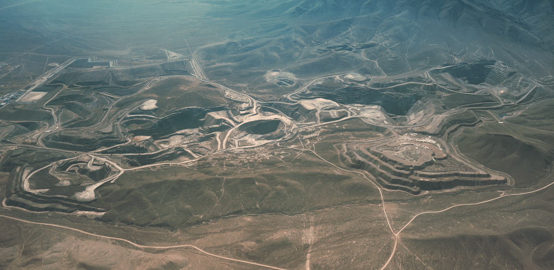
Today, manned aircraft, equipped with advanced sensors and imaging systems, are revolutionizing how mining companies approach mineral exploration, planning, operations, and reclamation. Aerial surveys offer a unique perspective, providing a comprehensive and cost effective means of acquiring vast quantities of geospatial data. This information empowers data-driven decisions at every stage of the mining lifecycle.
Partner with Synergy Mapping for Your Mining Surveying Needs
Benefit from our expertise in manned aircraft aerial surveying and unlock the full potential of your mining operations.
Contact Synergy Mapping, Inc.LiDAR: Unveiling the Earth’s Hidden Secrets with Laser Precision
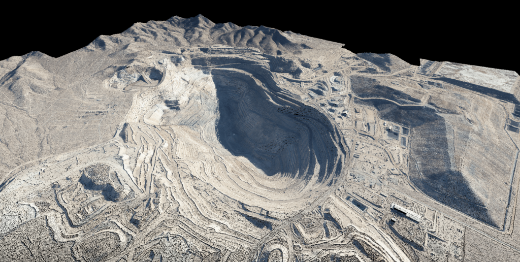
Airborne laser scanning, or LiDAR, is a powerful tool for capturing detailed 3D terrain information. Mounted on a manned aircraft, a LiDAR system emits laser pulses, generating a dense “point cloud” of data. This point cloud is processed to create accurate DEMs, DTMs, and other geospatial products. LiDAR’s ability to penetrate vegetation is invaluable for exploring areas with dense forest cover, revealing hidden geological features. LiDAR allows us to accurately measure and map terrain.
Benefits of LiDAR in Mining:
- Efficient Exploration: Quickly map large areas, even under dense vegetation.
- Detailed Terrain Analysis: Create highly accurate DEMs and DTMs.
- Resource Assessment: Identify potential ore deposits and estimate volumes.
- Reduced Exploration Costs: Minimize the need for extensive ground surveys.
Photogrammetry: Creating a Detailed Visual Record of the Mining Landscape
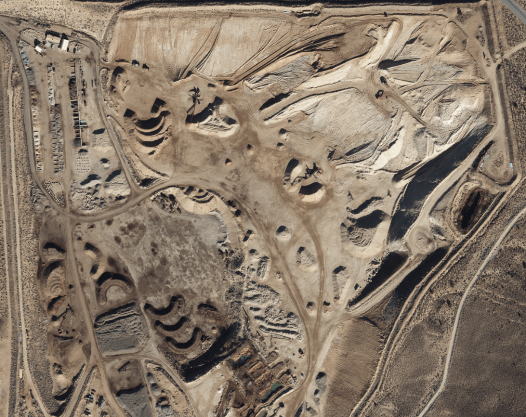
Aerial photogrammetry, a form of remote sensing, involves capturing overlapping aerial photography and processing them to generate detailed orthomosaics, DSMs, and 3D Modeling. These products provide a rich visual record of the mining site, enabling engineers and planners to visualize the terrain, identify hazards, and design optimal mine layouts. Photogrammetry also plays a crucial role in monitoring mining operations, tracking progress, and measuring stockpile volumes.
Applications of Photogrammetry in Mining:
- Mine Planning and Design: Create detailed maps and 3D models for optimal mine layout.
- Progress Monitoring: Track the progress of mining operations over time.
- Stockpile Management: Accurately measure stockpile volumes for inventory control.
- Environmental Monitoring: Assess environmental impacts and track reclamation efforts.
Visualize Your Mine with Stunning 3D Models
Leverage aerial photogrammetry to create high-resolution 3D models for enhanced mine planning, analysis, and communication.
Explore Photogrammetry ServicesAirborne LiDAR: Adapting to Diverse Project Needs

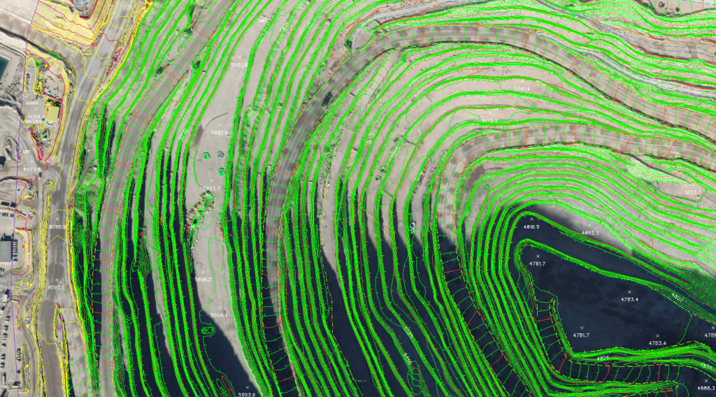
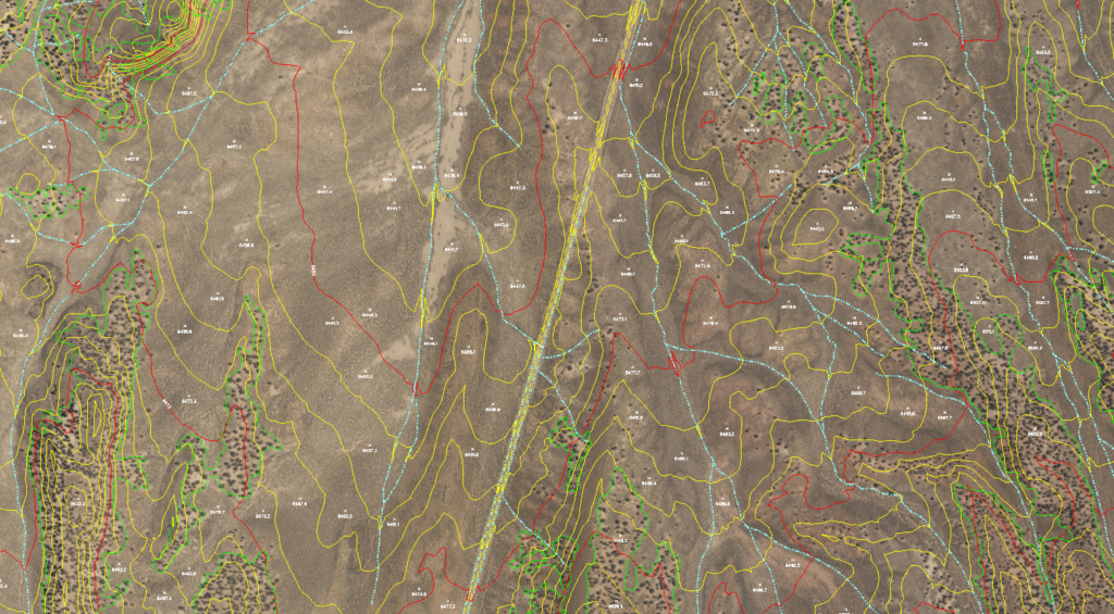
Airborne LiDAR goes beyond providing a broad overview—it delivers highly detailed survey data for specific areas. It captures dense point clouds that reveal intricate features of rock faces, open-pit walls, and other critical structures, enabling precise volumetric measurements and other valuable insights. LiDAR systems can be adjusted to collect varying point densities, measured in points per square meter (PPSM), to suit diverse applications. This allows for efficient and accurate data acquisition tailored to specific project needs.
For example, a large-scale mapping project might require a lower point density to efficiently cover a vast area, while a detailed engineering survey might necessitate a higher point density to capture fine-scale features with centimeter-level accuracy.
Additionally, LiDAR data collected can be classified to categorize different features within the point cloud. This classification process helps to differentiate between various elements such as vegetation, buildings, and ground features, making it easier to analyze and interpret the data. For example, classifying vegetation allows for more accurate 3D models of the bare-earth terrain, which is crucial for mine planning and design.
Synergy Mapping leverages its expertise in LiDAR data acquisition and processing to provide clients with comprehensive and insightful geospatial products. Our ability to adjust point density and classify LiDAR data ensures that we deliver the most relevant and valuable information for your specific project needs.
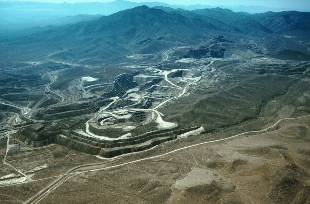
A Case Study in Success: The Gold Rock Survey and Mapping Project
The Gold Rock Survey and Mapping project powerfully demonstrates the value of aerial surveying in the mining industry. This project, completed by Synergy Mapping, Inc., showcases how manned aircraft and advanced surveying technology can deliver critical data and insights for large-scale mining operations. Specifically, Synergy Mapping provided a comprehensive suite of geospatial services to the Gold Rock project, including:
- Digital Terrain Modeling (DTM): Advanced DTMs with 5-foot contour intervals for precise elevation data and topographic analysis.
- Color Aerial Photography: Wide-area aerial imagery captured at a scale of 1”=1500’ (1:18,000) for a comprehensive site visualization.
- Color Oblique Photos: Angled aerial imagery for enhanced site visualization and terrain/infrastructure analysis.
- Color Digital Orthophotos: High-resolution, geo-referenced orthophotos for precise visual data and detailed mapping.
- Aerotriangulation: Geometric alignment of aerial imagery for a seamless and accurate geospatial foundation.
- Planimetric Mapping: Detailed representation of surface features, including natural formations and infrastructure.
This project highlights how Synergy Mapping used these tools to provide the client with a comprehensive understanding of the terrain and other key site characteristics, enabling informed decisions for mine planning, infrastructure development, and resource management across the expansive 54-square-mile site. The Gold Rock project exemplifies how aerial surveying can enhance efficiency, improve accuracy, and streamline operations for large-scale mining projects.
Unlock the Power of LiDAR for Your Mining Projects
Discover the unparalleled precision and efficiency of LiDAR aerial surveying for enhanced exploration, planning, and resource assessment.
Explore LiDAR ServicesThe Indispensable Role of Aerial Surveying in Modern Mining
Using Manned aircraft in aerial surveying and incorporating LiDAR, photogrammetry, and terrestrial laser scanning, represents the leading edge of surveying mines. These technologies provide the accurate, comprehensive data that modern mining companies need.
As mining evolves, these techniques will play an increasingly vital role in unlocking earth’s resources while minimizing environmental impacts. Detailed mapping of sites is essential, and aerial surveying provides this efficiently. Aerial survey companies are playing a major role in the mining industry.
A Clear Vision for the Future of Mining
The mining industry stands at a critical juncture. Balancing the increasing demand for resources with the imperative for sustainable practices requires innovative solutions and a commitment to precision. As we’ve explored, aerial surveying, utilizing manned aircraft and cutting-edge technologies like LiDAR, photogrammetry, and terrestrial laser scanning, offers a transformative approach to mining and mine surveying operations.
From efficient exploration and optimized mine planning to streamlined operations and responsible reclamation, the data and insights provided by aerial surveying are invaluable. Aerial imagery combined with LiDAR offers a powerful solution.
Frequently Asked Questions
What are Unmanned Aerial Systems (UAS)?
Unmanned Aerial Systems (UAS), sometimes referred to as drones, are aircraft without a human pilot on board. While some industries utilize UAS for certain applications, this article focuses on the advantages and specialized capabilities of manned aircraft aerial surveying for mining projects, particularly when large areas, high precision, and specific sensor payloads are required.
What is LiDAR technology?
LiDAR (Light Detection and Ranging) is a remote sensing method that uses light in the form of a pulsed laser to measure distances to objects. A LiDAR system mounted on a manned aircraft emits these laser pulses, which bounce off the ground and other objects. The time it takes for the pulses to return to the sensor is used to calculate the distance, creating a highly detailed 3D representation of the terrain.
How does LiDAR work?
LiDAR systems work by emitting rapid laser pulses from a manned aircraft. These pulses strike the ground, vegetation, buildings, and other features. The sensor measures the precise time it takes for each pulse to return. This time measurement, combined with the known speed of light, allows the system to calculate the distance to the point of impact. Millions of these measurements are collected, forming a dense “point cloud” that represents the 3D shape of the surveyed area. Specialized software then processes this point cloud to create digital elevation models (DEMs), digital terrain models (DTMs), and other valuable geospatial products.
What is aerial photogrammetry?
Aerial photogrammetry is the science and art of obtaining reliable measurements and 3D models of objects from aerial photographs. In the context of mining, aerial photogrammetry, using manned aircraft, involves capturing overlapping photographs of a mining site from different angles. These photographs are then processed using specialized software to create accurate orthomosaics (geometrically corrected images), digital surface models (DSMs), and 3D models of the terrain.
How does photogrammetry work?
Aerial photogrammetry works by analyzing the geometric relationships between multiple overlapping aerial photographs. Sophisticated software identifies common points in the overlapping images and uses these points to calculate the precise position and orientation of the camera when each photo was taken. This information allows the software to create a 3D reconstruction of the terrain. The software can also generate orthophotos by correcting the geometric distortions in the aerial photographs, ensuring accurate measurements and mapping. These orthophotos and 3D models provide valuable information for mine planning, operations, and analysis.