Aerial Mapping and Surveying Projects
At Synergy Mapping, we understand the critical role that accurate geospatial data plays in successful project planning and execution. Our aerial mapping and surveying services provide clients with the insights they need to make informed decisions, optimize designs, and achieve project objectives efficiently. Discover how our expertise can benefit your next project.
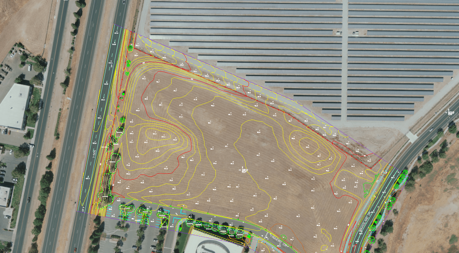
Energy
Vacaville, California
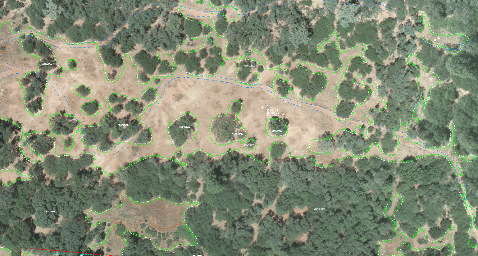
Synergy Mapping, in collaboration with GSP Consulting, executed the Vacaville Solar Mapping Project in Vacaville, California. This 12-acre renewable energy initiative provided essential topographic and spatial data for planning and developing solar energy infrastructure. Solar energy projects depend on precise geospatial data to maximize efficiency and optimize panel placement. Synergy Mapping leveraged advanced mapping technologies, including high-resolution aerial photography and contour mapping, to deliver actionable insights for informed decision-making. The Vacaville Solar project exemplifies Synergy Mapping’s expertise in renewable energy development, highlighting their commitment to providing accurate data tailored to the energy sector.
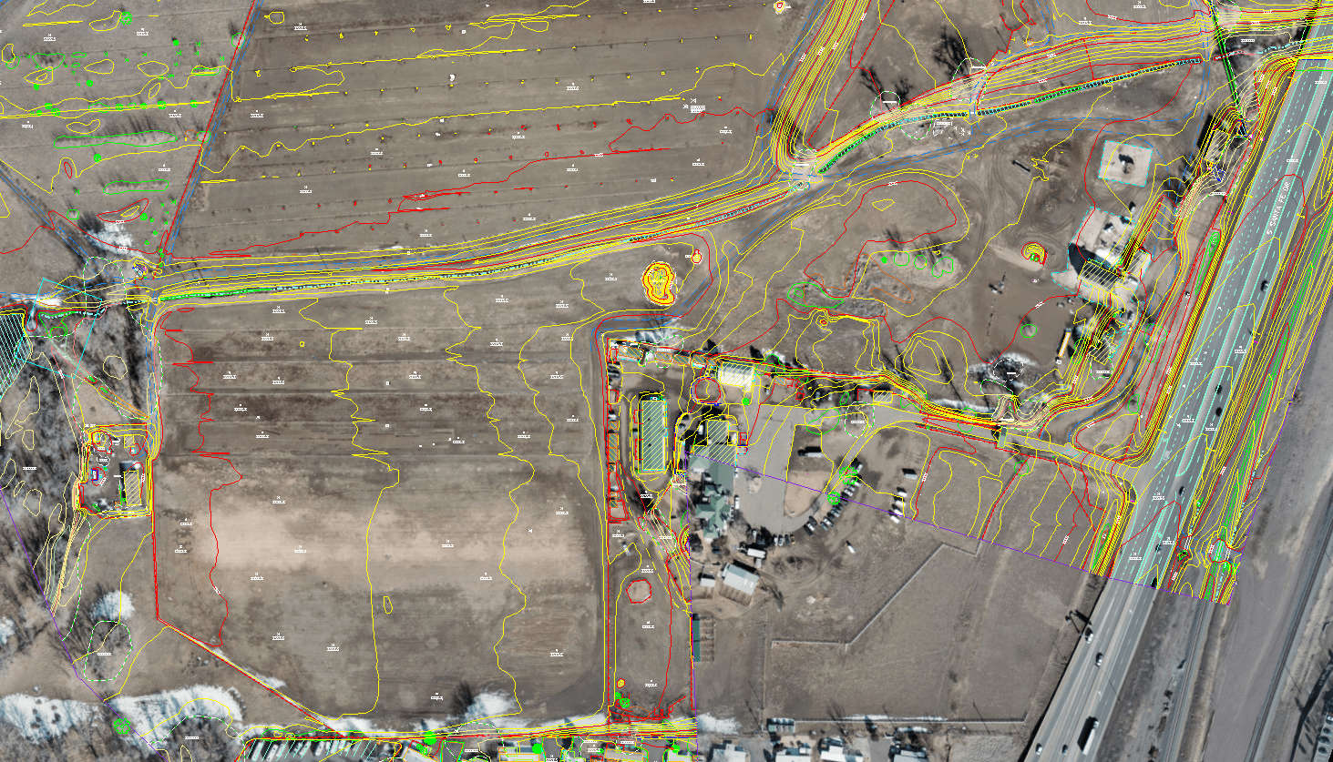
Agriculture
Littleton, Colorado
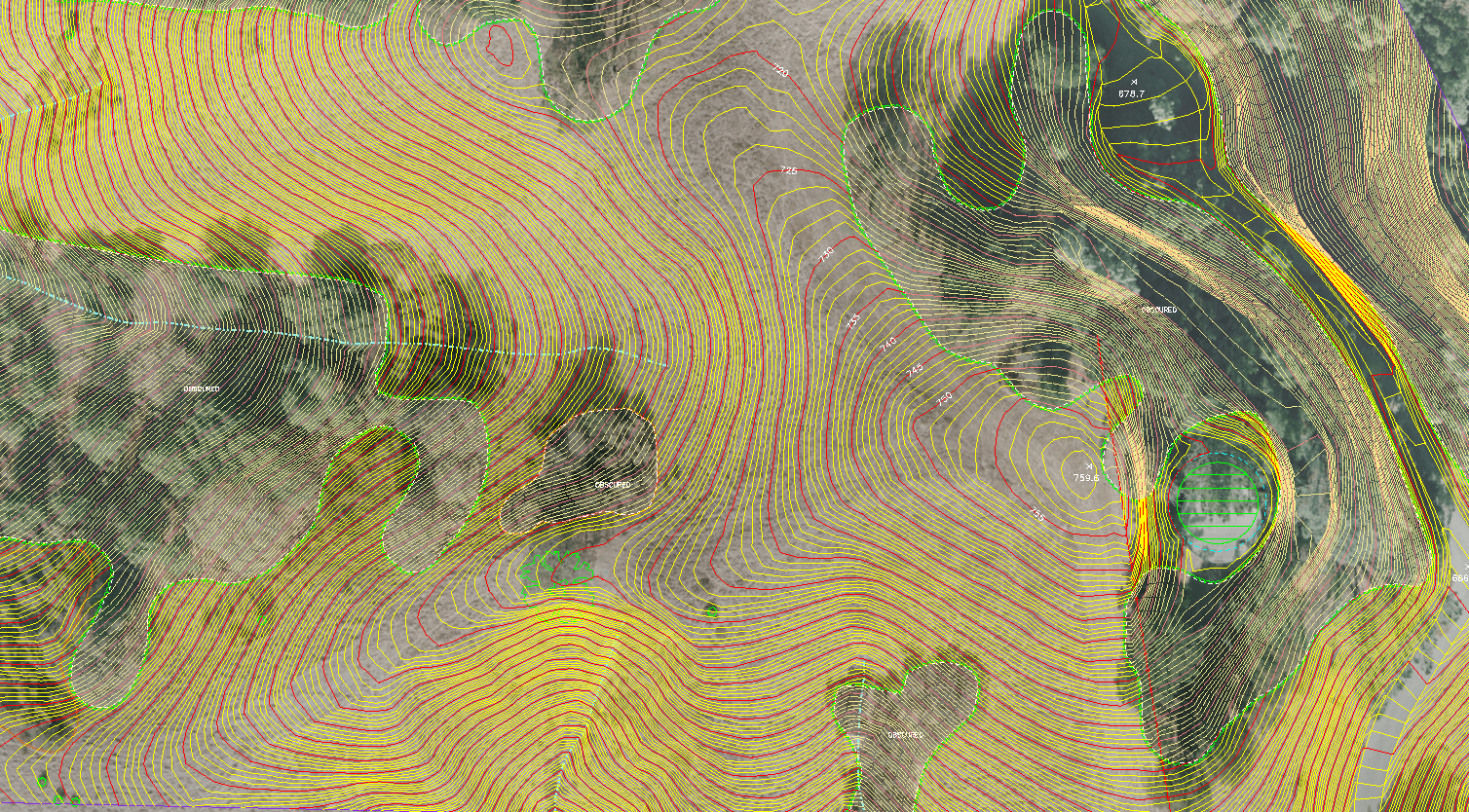
Synergy Mapping, Inc. provided advanced aerial surveying and mapping services for the Santa Fe Agricultural Mapping Project in Littleton, Colorado. This large-scale project covered 118 acres, focusing on generating high-resolution mapping data for agricultural land assessment and future planning. Agricultural projects demand precise geospatial data to inform decisions on land utilization and infrastructure planning. Synergy Mapping utilized state-of-the-art aerial photography and digital terrain modeling to deliver actionable insights. These datasets provided stakeholders with critical information to evaluate the site, optimize agricultural planning, and support sustainable development.
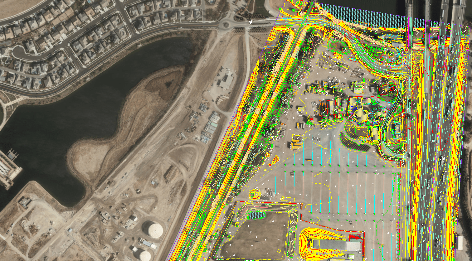
Water
Tracy, California
Synergy Mapping, in collaboration with GSP Consulting, conducted the River Islands Levee Mapping Project in Tracy, California. This topographic mapping initiative supported engineering efforts for water management and levee infrastructure development. The project encompassed a 1.5-mile-long strip, demanding exceptional precision to meet engineering and regulatory standards. Utilizing advanced mapping technologies, including high-resolution aerial photography and contour modeling, Synergy Mapping delivered geospatial datasets tailored to the project’s challenges. These datasets provided stakeholders with actionable insights for levee planning, grading, and post-construction analysis. The project aimed to provide detailed terrain and surface feature data for effective engineering designs.

Transportation
Roxborough Park, Colorado
Synergy Mapping, Inc. provided comprehensive aerial surveying and mapping services for the Rampart Range Road Mapping Project in Roxborough Park, Colorado. This 30-acre transportation-focused initiative required detailed geospatial data for road planning and infrastructure development. Effective transportation planning relies on accurate topographic and spatial data. Synergy Mapping utilized advanced mapping technologies, including high-resolution aerial photography and digital terrain modeling, to deliver actionable insights. This project highlights Synergy Mapping’s expertise in transportation infrastructure development, showcasing their ability to deliver precise and timely geospatial solutions for complex projects.
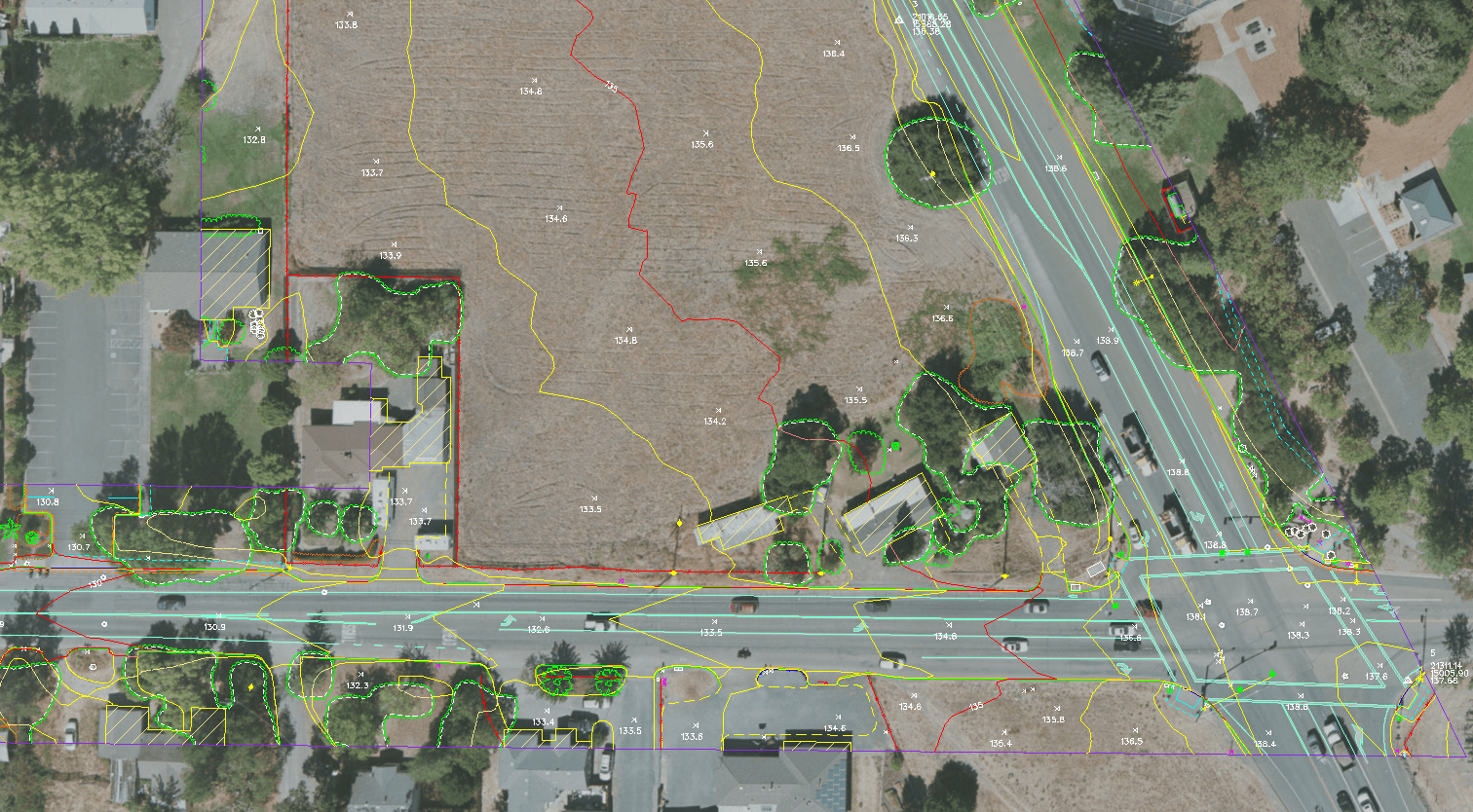
Transportation
Windsor, California
Synergy Mapping, in collaboration with GSP Consulting, executed advanced topographic mapping services for the Old Redwood Highway & Shiloh Road Mapping Project in Windsor, California. This 8-acre development initiative provided precise geospatial data for transportation planning and infrastructure improvements. Synergy Mapping employed a comprehensive suite of mapping technologies, including aerial photography and contour modeling, to deliver detailed surface and terrain data. This data enabled stakeholders to understand the site’s layout, assess its potential, and confidently plan infrastructure improvements. This project exemplifies Synergy Mapping’s ability to tackle complex transportation challenges with customized geospatial solutions, supporting timely and successful project execution.

Real Estate
Castle Rock, Colorado
Synergy Mapping, Inc. provided advanced topographic mapping services for the Oaks at Castle Rock project, a 170-acre real estate development in Castle Rock, Colorado. The development required precise geospatial data for planning, grading, and infrastructure design. Due to the site’s varied terrain and scale, a comprehensive approach to topographic mapping was required. Synergy Mapping leveraged cutting-edge technologies, including high-density LiDAR mapping and high-resolution aerial photography, to deliver actionable insights. The Oaks at Castle Rock project highlights Synergy Mapping’s ability to manage large-scale real estate initiatives while meeting the highest standards of precision and quality.
Commercial Real Estate
Cameron Park, California
Synergy Mapping, in partnership with GSP Consulting, provided comprehensive aerial surveying and mapping services for the Moonraker Mapping Project in Cameron Park, California. This 20-acre commercial real estate project required precise geospatial data to guide land assessment, infrastructure design, and zoning compliance. Synergy Mapping deployed advanced technologies, including high-resolution aerial photography and contour mapping, to generate reliable datasets for stakeholders. This project highlights their expertise in addressing the challenges of commercial land-use projects while delivering high-quality geospatial solutions tailored to the site’s specific needs.
Transportation
Lafayette, California
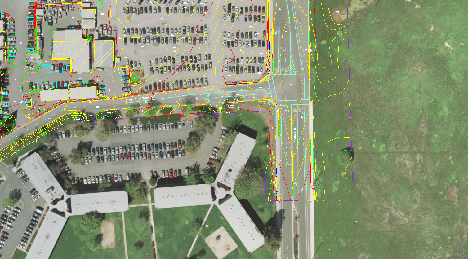
Synergy Mapping, in partnership with GSP Consulting, provided advanced topographic mapping services for the Monticello Mapping Project in Lafayette, California. This transportation-focused project was crucial for planning road widening and infrastructure improvements along Monticello Road. Covering 22 acres, the project required accurate geospatial data to ensure efficient roadway design. Synergy Mapping rose to the challenge by delivering actionable insights tailored to the project’s needs. They leveraged cutting-edge mapping technologies to ensure the project met its objectives with precision and reliability, highlighting their ability to manage complex geospatial tasks and provide stakeholders with the tools they need for successful infrastructure improvements.
Commercial Real Estate
Rancho Cordova, California
Synergy Mapping, in partnership with GSP Consulting, executed a topographic mapping project for the Mather VA Hospital site in Rancho Cordova, California. This initiative supported commercial real estate development on a sprawling 45-acre property, requiring detailed geospatial data to guide planning, infrastructure design, and site grading. Synergy Mapping provided advanced mapping services, including aerial photography, planimetric mapping, and contour generation. By combining cutting-edge technology with meticulous attention to detail, the team delivered actionable insights that enabled stakeholders to make confident, informed decisions for the site’s development.
Transportation
Centennial, Colorado
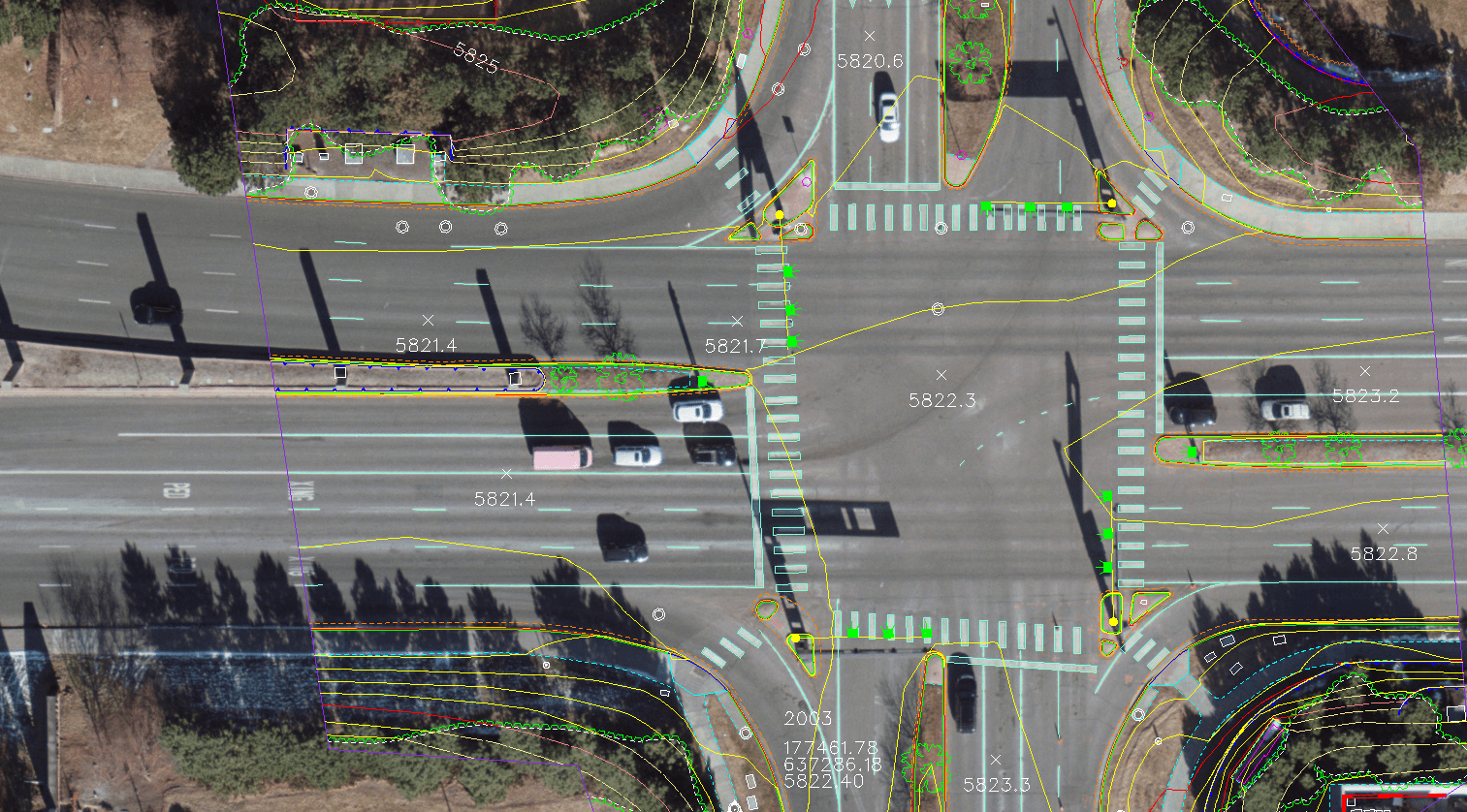
Synergy Mapping, Inc. delivered a high-precision aerial surveying and mapping solution for a transportation project along Inverness Drive West in Centennial, Colorado. This effort provided reliable data to support transportation planning, infrastructure development, and long-term roadway enhancements. Inverness Drive West posed unique challenges requiring advanced techniques and state-of-the-art technology to ensure data accuracy. The survey covered the entire right-of-way, capturing precise topographic, elevation, and feature data essential for planning and design. This project underscores Synergy Mapping’s expertise in tackling complex urban surveying challenges.

Mining
Eureka, Nevada
Synergy Mapping Inc. delivered an extensive geospatial survey and mapping solution for the Gold Rock mining project in Eureka, Nevada. Spanning 54 square miles, this initiative provided comprehensive data to support mining operations and future land-use planning. The project required cutting-edge technology and expert execution to ensure accurate data collection and analysis in this geologically complex and remote location. Through aerial surveying, advanced mapping techniques, and precise data modeling, Synergy Mapping empowered stakeholders with actionable insights to optimize mining operations and land management strategies.

Commercial Real Estate
Broomfield, Colorado
Synergy Mapping delivered high-precision geospatial services for the Flatirons Mall commercial real estate development in Broomfield, Colorado. Covering 41 acres, the project provided critical geospatial data for property planning, infrastructure design, and long-term development strategies. Advanced aerial surveying and mapping techniques delivered actionable insights for efficient planning and decision-making. Synergy Mapping’s commitment to precision and timeliness ensured the project’s success, showcasing their ability to manage complex geospatial tasks while maintaining accuracy and reliability.
Energy
El Jebel, Colorado
Synergy Mapping spearheaded the Eagle LiDAR and Aerial Mapping Project in El Jebel, Colorado. This initiative provided cutting-edge geospatial solutions across 445 acres, supporting land-use planning and environmental analysis for the energy sector. Combining advanced LiDAR technology with high-resolution aerial imagery, Synergy Mapping delivered comprehensive datasets, enabling stakeholders to gain deep insights into the project area’s topography and surface features. This work was vital in balancing energy development with sustainable land management practices, demonstrating expertise in addressing complex geospatial challenges.
Water
Boulder, Colorado
Synergy Mapping played a key role in advancing the Boulder Water Main Project by providing specialized geospatial services tailored to the unique needs of water infrastructure planning. Located in Boulder, Colorado, this initiative focused on a 100-foot variable corridor that required high levels of precision and reliability in both data collection and analysis. Leveraging cutting-edge aerial surveying and mapping methodologies, Synergy Mapping delivered comprehensive datasets to aid in the planning, assessment, and long-term improvement of critical water infrastructure systems. The project ensured the seamless integration of new water main elements while maintaining operational continuity for existing infrastructure.
Agriculture
Littleton, Colorado
Synergy Mapping, Inc. provided advanced aerial surveying and mapping services for the Santa Fe Agricultural Mapping Project in Littleton, Colorado. This large-scale project covered 118 acres, focusing on generating high-resolution mapping data for agricultural land assessment and future planning. Agricultural projects demand precise geospatial data to inform decisions on land utilization and infrastructure planning. Synergy Mapping utilized state-of-the-art aerial photography and digital terrain modeling to deliver actionable insights. These datasets provided stakeholders with critical information to evaluate the site, optimize agricultural planning, and support sustainable development.
Commercial Real Estate
Cameron Park, California
Synergy Mapping, in partnership with GSP Consulting, provided comprehensive aerial surveying and mapping services for the Moonraker Mapping Project in Cameron Park, California. This 20-acre commercial real estate project required precise geospatial data to guide land assessment, infrastructure design, and zoning compliance. Synergy Mapping deployed advanced technologies, including high-resolution aerial photography and contour mapping, to generate reliable datasets for stakeholders. This project highlights their expertise in addressing the challenges of commercial land-use projects while delivering high-quality geospatial solutions tailored to the site’s specific needs.
Commercial Real Estate
Rancho Cordova, California
Synergy Mapping, in partnership with GSP Consulting, executed a topographic mapping project for the Mather VA Hospital site in Rancho Cordova, California. This initiative supported commercial real estate development on a sprawling 45-acre property, requiring detailed geospatial data to guide planning, infrastructure design, and site grading. Synergy Mapping provided advanced mapping services, including aerial photography, planimetric mapping, and contour generation. By combining cutting-edge technology with meticulous attention to detail, the team delivered actionable insights that enabled stakeholders to make confident, informed decisions for the site’s development.
Commercial Real Estate
Broomfield, Colorado
Synergy Mapping delivered high-precision geospatial services for the Flatirons Mall commercial real estate development in Broomfield, Colorado. Covering 41 acres, the project provided critical geospatial data for property planning, infrastructure design, and long-term development strategies. Advanced aerial surveying and mapping techniques delivered actionable insights for efficient planning and decision-making. Synergy Mapping’s commitment to precision and timeliness ensured the project’s success, showcasing their ability to manage complex geospatial tasks while maintaining accuracy and reliability.
Energy
Vacaville, California
Synergy Mapping, in collaboration with GSP Consulting, executed the Vacaville Solar Mapping Project in Vacaville, California. This 12-acre renewable energy initiative provided essential topographic and spatial data for planning and developing solar energy infrastructure. Solar energy projects depend on precise geospatial data to maximize efficiency and optimize panel placement. Synergy Mapping leveraged advanced mapping technologies, including high-resolution aerial photography and contour mapping, to deliver actionable insights for informed decision-making. The Vacaville Solar project exemplifies Synergy Mapping’s expertise in renewable energy development, highlighting their commitment to providing accurate data tailored to the energy sector.
Energy
El Jebel, Colorado
Synergy Mapping spearheaded the Eagle LiDAR and Aerial Mapping Project in El Jebel, Colorado. This initiative provided cutting-edge geospatial solutions across 445 acres, supporting land-use planning and environmental analysis for the energy sector. Combining advanced LiDAR technology with high-resolution aerial imagery, Synergy Mapping delivered comprehensive datasets, enabling stakeholders to gain deep insights into the project area’s topography and surface features. This work was vital in balancing energy development with sustainable land management practices, demonstrating expertise in addressing complex geospatial challenges.
Mining
Eureka, Nevada
Synergy Mapping Inc. delivered an extensive geospatial survey and mapping solution for the Gold Rock mining project in Eureka, Nevada. Spanning 54 square miles, this initiative provided comprehensive data to support mining operations and future land-use planning. The project required cutting-edge technology and expert execution to ensure accurate data collection and analysis in this geologically complex and remote location. Through aerial surveying, advanced mapping techniques, and precise data modeling, Synergy Mapping empowered stakeholders with actionable insights to optimize mining operations and land management strategies.
Real Estate
Castle Rock, Colorado
Synergy Mapping, Inc. provided advanced topographic mapping services for the Oaks at Castle Rock project, a 170-acre real estate development in Castle Rock, Colorado. The development required precise geospatial data for planning, grading, and infrastructure design. Due to the site’s varied terrain and scale, a comprehensive approach to topographic mapping was required. Synergy Mapping leveraged cutting-edge technologies, including high-density LiDAR mapping and high-resolution aerial photography, to deliver actionable insights. The Oaks at Castle Rock project highlights Synergy Mapping’s ability to manage large-scale real estate initiatives while meeting the highest standards of precision and quality.
Transportation
Roxborough Park, Colorado
Synergy Mapping, Inc. provided comprehensive aerial surveying and mapping services for the Rampart Range Road Mapping Project in Roxborough Park, Colorado. This 30-acre transportation-focused initiative required detailed geospatial data for road planning and infrastructure development. Effective transportation planning relies on accurate topographic and spatial data. Synergy Mapping utilized advanced mapping technologies, including high-resolution aerial photography and digital terrain modeling, to deliver actionable insights. This project highlights Synergy Mapping’s expertise in transportation infrastructure development, showcasing their ability to deliver precise and timely geospatial solutions for complex projects.
Transportation
Windsor, California
Synergy Mapping, in collaboration with GSP Consulting, executed advanced topographic mapping services for the Old Redwood Highway & Shiloh Road Mapping Project in Windsor, California. This 8-acre development initiative provided precise geospatial data for transportation planning and infrastructure improvements. Synergy Mapping employed a comprehensive suite of mapping technologies, including aerial photography and contour modeling, to deliver detailed surface and terrain data. This data enabled stakeholders to understand the site’s layout, assess its potential, and confidently plan infrastructure improvements. This project exemplifies Synergy Mapping’s ability to tackle complex transportation challenges with customized geospatial solutions, supporting timely and successful project execution.
Transportation
Lafayette, California
Synergy Mapping, in partnership with GSP Consulting, provided advanced topographic mapping services for the Monticello Mapping Project in Lafayette, California. This transportation-focused project was crucial for planning road widening and infrastructure improvements along Monticello Road. Covering 22 acres, the project required accurate geospatial data to ensure efficient roadway design. Synergy Mapping rose to the challenge by delivering actionable insights tailored to the project’s needs. They leveraged cutting-edge mapping technologies to ensure the project met its objectives with precision and reliability, highlighting their ability to manage complex geospatial tasks and provide stakeholders with the tools they need for successful infrastructure improvements.
Transportation
Centennial, Colorado
Synergy Mapping, Inc. delivered a high-precision aerial surveying and mapping solution for a transportation project along Inverness Drive West in Centennial, Colorado. This effort provided reliable data to support transportation planning, infrastructure development, and long-term roadway enhancements. Inverness Drive West posed unique challenges requiring advanced techniques and state-of-the-art technology to ensure data accuracy. The survey covered the entire right-of-way, capturing precise topographic, elevation, and feature data essential for planning and design. This project underscores Synergy Mapping’s expertise in tackling complex urban surveying challenges.
Water
Tracy, California
Synergy Mapping, in collaboration with GSP Consulting, conducted the River Islands Levee Mapping Project in Tracy, California. This topographic mapping initiative supported engineering efforts for water management and levee infrastructure development. The project encompassed a 1.5-mile-long strip, demanding exceptional precision to meet engineering and regulatory standards. Utilizing advanced mapping technologies, including high-resolution aerial photography and contour modeling, Synergy Mapping delivered geospatial datasets tailored to the project’s challenges. These datasets provided stakeholders with actionable insights for levee planning, grading, and post-construction analysis. The project aimed to provide detailed terrain and surface feature data for effective engineering designs.
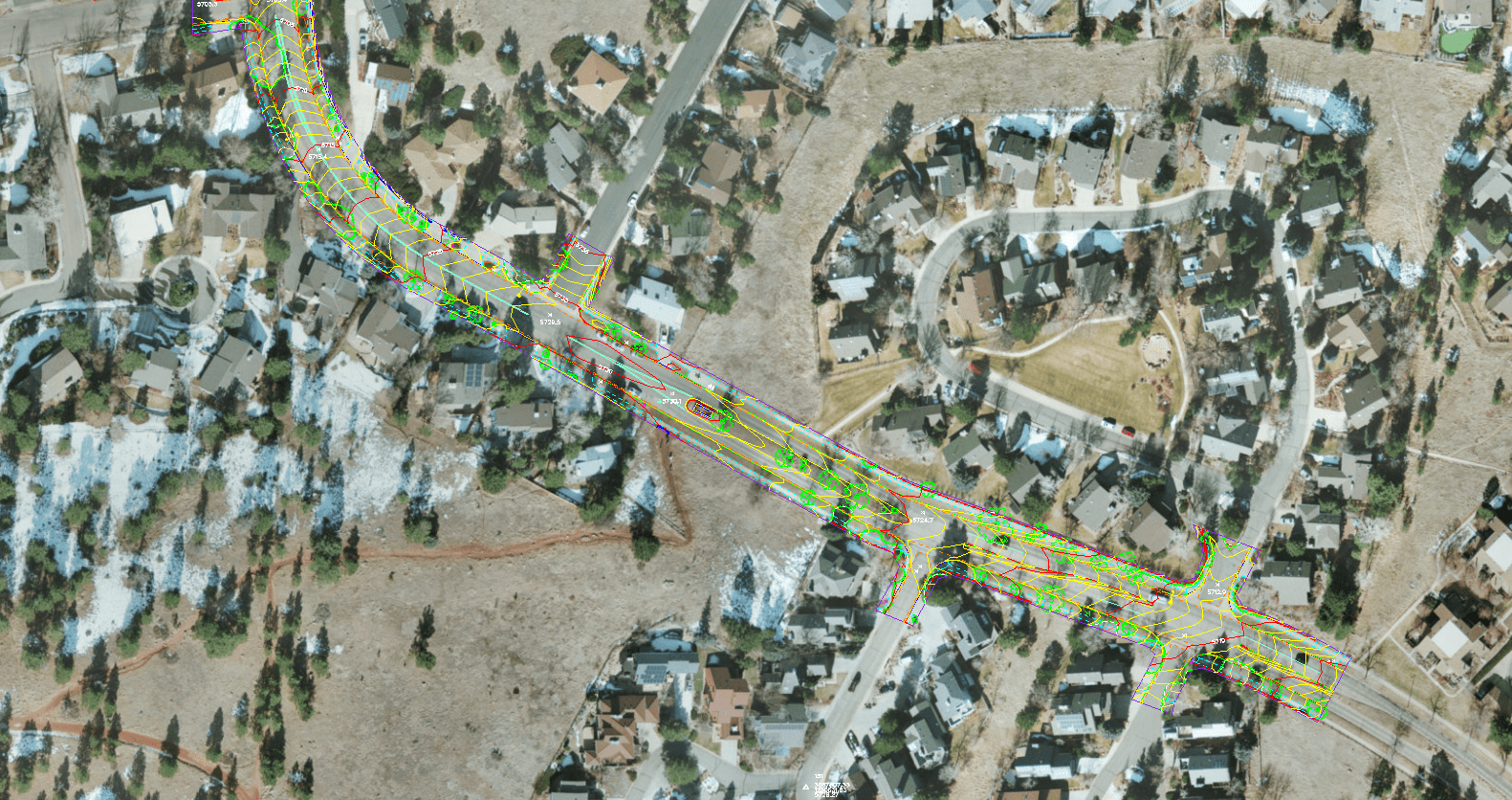
Water
Boulder, Colorado
Synergy Mapping played a key role in advancing the Boulder Water Main Project by providing specialized geospatial services tailored to the unique needs of water infrastructure planning. Located in Boulder, Colorado, this initiative focused on a 100-foot variable corridor that required high levels of precision and reliability in both data collection and analysis. Leveraging cutting-edge aerial surveying and mapping methodologies, Synergy Mapping delivered comprehensive datasets to aid in the planning, assessment, and long-term improvement of critical water infrastructure systems. The project ensured the seamless integration of new water main elements while maintaining operational continuity for existing infrastructure.
Contact us for industry-specific geospatial solutions.
Partner with Synergy Mapping for your next project and experience the difference that precise aerial mapping and surveying can make. Contact us today to discuss your project requirements and let our team help you make informed decisions, optimize designs, and achieve successful outcomes.
Get in Touch