River Islands Levee Survey and Mapping
Location: Tracy, California
Industry: Water
Project Overview
Synergy Mapping, Inc., in collaboration with GSP Consulting, conducted the River Islands Levee Mapping Project in Tracy, California. This comprehensive topographic mapping initiative played a pivotal role in supporting engineering efforts for water management and levee infrastructure development.
The project encompassed a 1.5-mile-long, 500-foot-wide strip, with an optional additional survey of a 500-acre parcel. Water management projects, particularly those involving levee construction, demand exceptional precision and reliability to meet the rigorous requirements of engineering and regulatory standards.
By utilizing advanced mapping technologies, including high-resolution aerial photography, planimetric mapping, and contour modeling, Synergy Mapping, Inc. delivered geospatial datasets tailored to the project’s unique challenges. These datasets provided stakeholders with actionable insights to inform levee planning, grading, and post-construction analysis, ensuring a successful and compliant development process.
Mapping Scope
The mapping scope of the River Islands Levee project focused on generating accurate and comprehensive geospatial datasets to support the planning and construction of levee infrastructure. The project aimed to provide detailed terrain and surface feature data to enable effective engineering designs, ensure regulatory compliance, and support sustainable water resource management.
Deliverables included:
1. High-Resolution Aerial Photography: Captured at a 4.5 cm ground sample distance (GSD) to ensure precise visualization of the project area.
2. Planimetric Mapping: Delivered accurate 2D representations of surface features, supporting a 1”=40’ map scale.
3. Contour Mapping: Derived from a Digital Terrain Model (DTM), one-foot contour intervals provided essential elevation data for grading and post-construction evaluations.
These datasets formed a solid foundation for planning and decision-making, ensuring the project met both immediate and long-term goals.

Challenges and Solutions
Water infrastructure projects like the River Islands Levee Mapping Project often encounter challenges related to precision, regulatory compliance, and environmental considerations. Synergy Mapping, Inc. addressed these challenges through innovative approaches and state-of-the-art technology.
Challenge 1
Meeting the Specific Needs of Water Engineering Projects Requiring High Precision
Water management projects demand highly accurate data to guide infrastructure design, particularly for levees, which must be engineered to withstand water pressure, prevent flooding, and protect adjacent areas.
Solution 1
Advanced Mapping Methodologies for High-Precision Data
To meet these requirements, Synergy Mapping, Inc. utilized advanced aerial photography and mapping techniques tailored to the unique demands of water engineering. High-resolution aerial imagery was captured at a 4.5 cm GSD, offering detailed visualization of the project area’s surface features and infrastructure.
Additionally, Digital Terrain Modeling (DTM) was employed to produce one-foot contour intervals. These contours provided stakeholders with the precise elevation data necessary for grading, drainage design, and levee construction. By integrating high-resolution imagery with advanced terrain modeling, Synergy Mapping, Inc. ensured that all deliverables met the accuracy standards required for successful water resource management.
Challenge 2
Addressing Environmental and Regulatory Considerations in Mapping Data
Water infrastructure projects are subject to strict environmental and regulatory standards that must be adhered to throughout the planning and construction phases. Ensuring compliance is critical to project success and long-term sustainability.
Solution 2
High-Quality Imagery and Mapping Tailored to Regulatory Standards
Synergy Mapping, Inc. delivered high-quality aerial imagery and detailed mapping that aligned with regulatory requirements for water management projects. These datasets provided stakeholders with the data needed to address environmental considerations and meet all applicable regulations.
By proactively addressing regulatory requirements during the mapping phase, Synergy Mapping, Inc. minimized risks associated with non-compliance and ensured the project adhered to all necessary standards, supporting its smooth progression.
Services Provided
Synergy Mapping, Inc. delivered a comprehensive range of geospatial services tailored to the River Islands Levee project’s specific requirements. Each service was designed to ensure precision, reliability, and compatibility with engineering workflows, enabling stakeholders to make informed decisions confidently.
Service 1
Color Aerial Photography
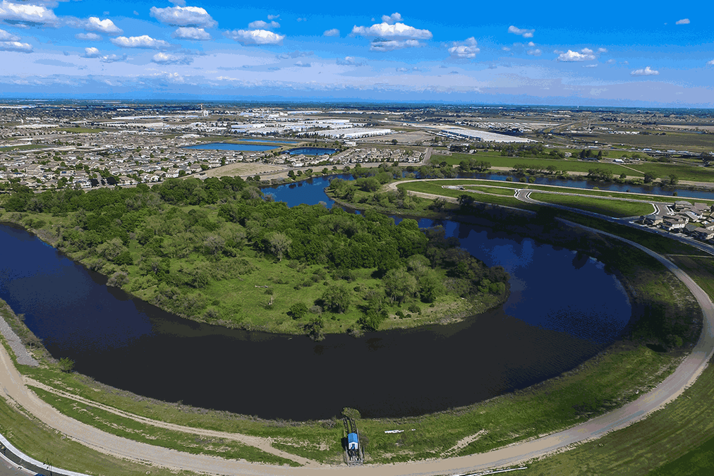
High-resolution aerial imagery was captured at a 4.5 cm GSD, providing stakeholders with a detailed and accurate visual representation of the 1.5-mile-long project area and the optional 500-acre parcel. This imagery served as the foundation for all subsequent mapping efforts, enabling stakeholders to visualize terrain, infrastructure, and surface features clearly.
The aerial imagery highlighted key features, including existing infrastructure, vegetation, and topographic changes, offering a comprehensive view of the site.
Service 2
Planimetric Mapping
Planimetric mapping provided precise 2D representations of surface features, including levees, vegetation, and man-made structures. These maps were critical for understanding the site’s layout and planning levee construction effectively.
By delivering detailed planimetric maps, Synergy Mapping, Inc. ensured stakeholders could identify and incorporate critical surface features into their engineering designs, aligning with the project’s water management objectives.
Service 3
Contour Mapping
Contour maps with one-foot intervals were derived from the Digital Terrain Model (DTM) to provide precise elevation data. Supporting a 1”=40’ map scale, these contours were essential for planning grading, drainage, and levee infrastructure.
The contour mapping allowed stakeholders to visualize the project area’s topography in detail, enabling them to design infrastructure improvements that aligned seamlessly with the natural terrain.
Benefits of Working
with Synergy Mapping, Inc.
By partnering with Synergy Mapping, Inc., stakeholders in the River Islands Levee project gained access to cutting-edge geospatial expertise and state-of-the-art mapping solutions. The company’s commitment to precision and quality ensured that all deliverables were reliable, actionable, and tailored to the unique needs of water resource management and infrastructure development.
The geospatial datasets provided by Synergy Mapping, Inc. empowered stakeholders to:
1. Streamline Planning and Design Workflows: High-resolution data facilitated seamless integration into engineering tools, reducing project timelines and enhancing productivity.
2. Enhance Decision-Making: Accurate mapping and elevation data provided actionable insights that supported effective planning for levee construction and post-construction analysis.
3. Ensure Regulatory Compliance: The deliverables met or exceeded all relevant environmental and infrastructure standards, minimizing risks and ensuring project success.
This project underscores Synergy Mapping, Inc.’s ability to deliver customized geospatial solutions that address the complex challenges of water management and infrastructure development projects.

Your Trusted Geospatial Partner for Water Resource Management Projects
Synergy Mapping, Inc. specializes in delivering advanced geospatial solutions tailored to the unique needs of water resource management and infrastructure development. From high-resolution aerial imagery to detailed elevation modeling, our services provide the precision and reliability required for successful project execution. Contact Us today to enhance your water resource management project with accurate and actionable geospatial data. Synergy Mapping, Inc. is here to help, learn how our expertise can support your goals and deliver exceptional results.
Get in Touch
