Stockpile Volume Measurement Services
Are you searching for “Stockpile Volume Measurement Services Near Me?”
Are you managing large stockpiles and need precise volume calculations to streamline your inventory processes? Synergy Mapping, Inc. specializes in high-accuracy stockpile volume measurement services that cater to California, Nevada, Colorado and the entire United States. We work with a diverse range of industries including construction, mining, power plants, and more. Contact us today to enhance your stockpile management with cutting-edge aerial photogrammetry technology.
At Synergy Mapping, Inc., we don’t just measure—we enhance your operational efficiency through precision. Our stockpile volume measurement services employ the latest in aerial photogrammetry and LiDAR technologies, ensuring not only accurate volume calculations but also data that empower better decision-making. Whether you’re in mining, construction, or any industry requiring detailed inventory management, our state-of-the-art techniques and seasoned experts are dedicated to providing solutions that save time, reduce costs, and optimize your resources. Connect with us to see how precise measurements can transform your stockpile management.

An Introduction to Synergy Mapping, Inc.
Synergy Mapping, Inc. stands as a leader in geospatial surveying and digital mapping, utilizing advanced aerial photogrammetry techniques to deliver detailed and accurate measurements. Our expertise extends beyond simple mappings; we provide comprehensive stockpile volume measurement services essential for effective inventory and project management across various sectors. With over 75 years of combined experience and adherence to stringent industry standards, our solutions ensure precision, reliability, and unmatched quality.
Maximize Your Resource Efficiency
Ensure precision in your stockpile management with our state-of-the-art volume measurement services.
Contact Synergy Mapping, Inc. today—to optimize your resource allocation and operational efficiency.We cater to a range of industries
At Synergy Mapping, Inc., we understand that each industry faces unique stockpile management challenges. Our specialized services, leveraging advanced aerial photogrammetry and LiDAR technologies, provide precise and reliable volume measurements essential for inventory management and operational efficiency. From construction and mining to agriculture and archaeology, our tailored solutions empower businesses to enhance decision-making and maintain optimal control over their stockpiles.
Construction
Our advanced aerial photogrammetry and LiDAR technologies provide exact material estimates for construction projects, preventing over or under-ordering. This precision streamlines project workflows from foundation to finish, ensuring timelines and budgets are met with increased accuracy.
Power Plants
For power plants, precise management of coal and bulk materials is crucial. Our volume measurement services enhance inventory accuracy, ensuring optimal stock levels and operational continuity while supporting compliance with environmental regulations.
Salt Production
In salt production, precise stockpile measurements affect both production planning and market supply. Our aerial surveys deliver accurate volume data, enabling better responsiveness to market demands and optimizing production cycles for enhanced profitability.
Mining
Our precise volume measurements are essential in mining for monitoring extracted materials against production targets. This accuracy improves resource management, regulatory compliance, and operational sustainability, increasing overall efficiency.
Landfills
Accurate volume assessments in landfill management optimize space usage and extend site lifespan. Our measurements are crucial for planning expansions and estimating closure timelines, helping operators comply with environmental standards.
Waste Management
In waste management, knowing exact stockpile volumes of recycled materials enhances operational efficiency. Our measurements assist in resource allocation and waste collection scheduling, supporting effective and sustainable practices.
Agriculture
Accurate volume data for agricultural bulk materials like feed and grains aid in managing inventory and forecasting production. Our services enhance decision-making regarding distribution and storage, improving market responsiveness and financial performance.
Archaeology
For archaeology, precise volume measurements of soil and artifacts are vital for site analysis and historical documentation. Our data aids in excavation strategies and artifact preservation, enriching academic research and understanding of archaeological sites.
Enhance Your Inventory Accuracy
Contact Synergy Mapping, Inc. for a consultation on transforming your stockpile volume measurements into actionable insights. Perfect your inventory processes with our advanced aerial technology.
Contact Synergy Mapping, Inc.Benefits of Using Synergy Mapping, Inc.
At Synergy Mapping, Inc., we leverage cutting-edge technology and extensive industry expertise to deliver unparalleled services in stockpile volume measurement. Our commitment to precision, efficiency, and customization ensures that our clients receive not only data but actionable insights that drive operational success across diverse industries.
Precision and Accuracy: Utilizing the latest in aerial sensors and sophisticated platforms, our services ensure measurements with high precision. This accuracy is critical in industries where even small miscalculations can lead to significant errors, ensuring that all data reflects true stockpile volumes.
Efficiency: Our state-of-the-art technology enables rapid data collection and processing, minimizing downtime for our clients. This swift turnaround accelerates decision-making processes, allowing businesses to react quickly to changing conditions and maintain a competitive edge.
Cost-Effective: By providing exact measurements, our services help avoid the costly consequences of inaccuracies, such as over-purchasing or resource shortages. This precision translates into substantial cost savings by optimizing resource allocation and reducing waste.
Comprehensive Reporting: We deliver detailed, easy-to-understand reports that integrate seamlessly into existing project management systems. These reports provide a clear overview of stockpile quantities and spatial data, supporting thorough analysis and strategic planning.
Customizable Solutions: Recognizing that each industry has distinct requirements, our services are highly customizable. We tailor our solutions to meet specific project demands, addressing unique challenges and providing targeted insights that are most relevant to each client’s operational needs.
Our Stockpile Volume Measurement Services
Synergy Mapping, Inc. offers a comprehensive suite of stockpile volume measurement services designed to provide accurate, reliable data for industries managing large quantities of materials. From aerial photogrammetry to detailed visualization and mapping, our advanced technologies ensure that every measurement is precise, helping businesses streamline their operations and enhance efficiency.
Aerial Photogrammetry
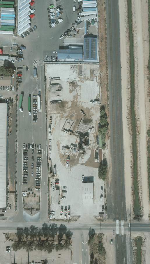
Utilizing high-resolution cameras mounted on manned aircraft, we capture detailed images of stockpiles from multiple angles. This data is then processed using sophisticated software to create precise 3D models of the stockpiles, providing accurate volume measurements and detailed topographical information.

LiDAR Scanning
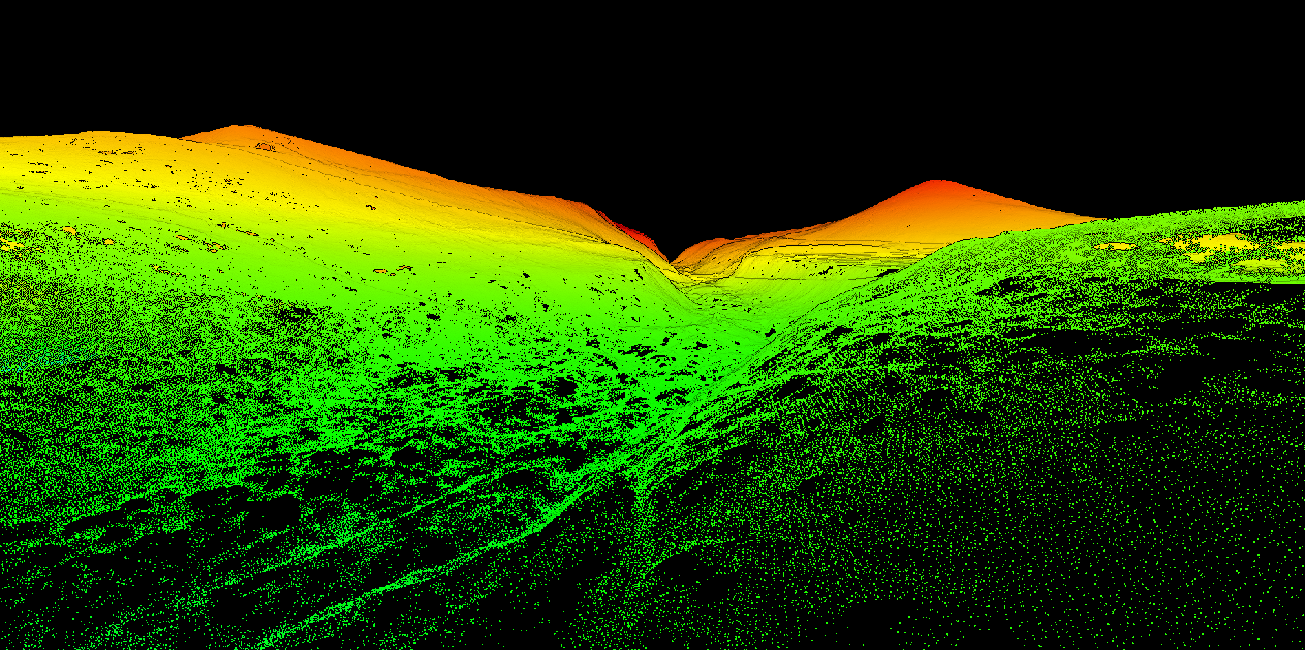
Our LiDAR scanning technology uses laser light to generate high-density data points. This method is especially effective in complex environments where precision is critical, allowing us to measure stockpile volumes with exceptional accuracy and detail, even in cluttered or obstructed areas.
Detailed Visualization and Mapping
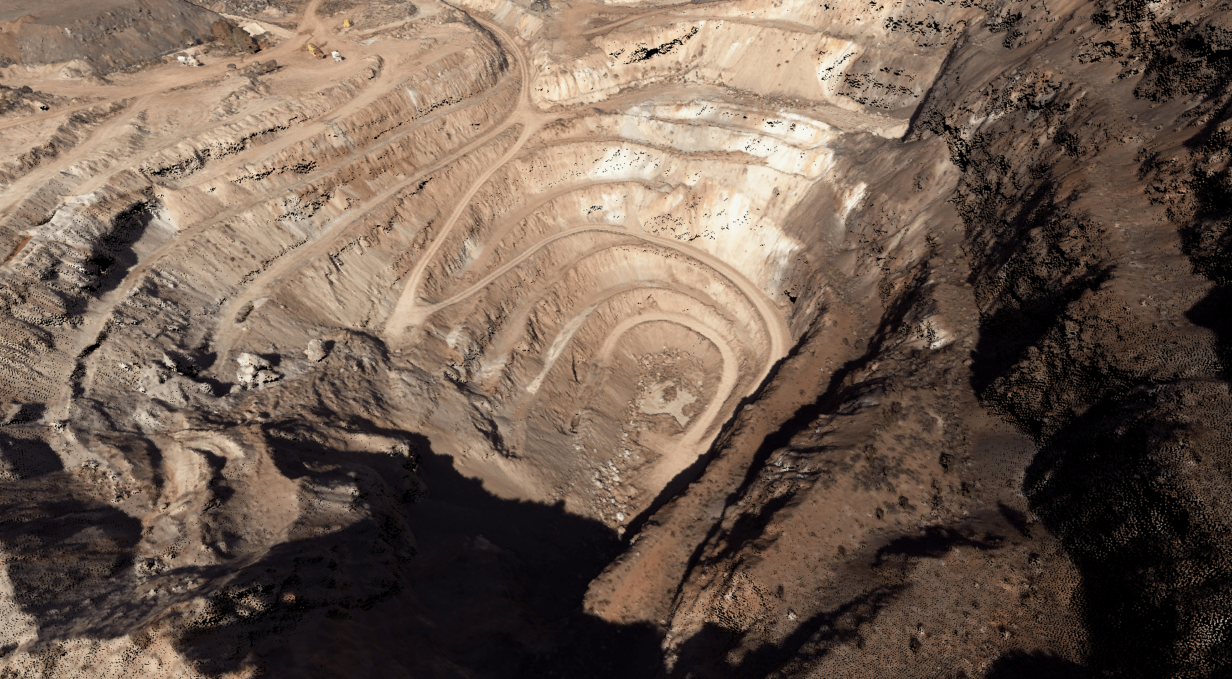
Our services include advanced visualization and mapping capabilities that provide comprehensive views of stockpile sites. These detailed maps and models are essential for planning, analysis, and reporting, aiding in operational planning and compliance documentation.
Optimize Your Operational Workflow
Leverage our precise and reliable stockpile measurement solutions to streamline your operations. Call now and take the first step towards operational excellence with enhanced data accuracy.
Contact Synergy Mapping, Inc.Why Choose Synergy Mapping, Inc.?
Choosing Synergy Mapping, Inc. means selecting a partner committed to precision, reliability, and innovative solutions in geospatial surveying. Our extensive industry experience, coupled with cutting-edge technology and a client-centric approach, ensures that every project we undertake is executed with the highest standards of quality and tailored to meet specific industry needs.

Industry Expertise
With decades of experience, our team possesses a profound understanding of geospatial surveying and digital mapping. This deep-rooted knowledge allows us to handle complex projects across a variety of industries, from mining to environmental management, delivering results that are not only accurate but also actionable.

Advanced Technology
We are at the forefront of technological integration in geospatial services, utilizing the latest advancements in aerial photogrammetry and LiDAR technology. These technologies enable us to capture and analyze data with an exceptional degree of accuracy, providing detailed insights that traditional methods cannot achieve.

Customized Service
We recognize that each industry and project has unique challenges and requirements. Our approach is to tailor every service package to fit the specific demands of each client, ensuring that the solutions we provide are perfectly aligned with their operational and strategic goals.

Quality Assurance
We adhere strictly to the highest industry standards and maintain rigorous quality control processes throughout every phase of our projects. This commitment to quality ensures that all services meet or exceed the requirements set by governing bodies and client expectations alike.

Client Satisfaction
Our dedication to exceeding client expectations is reflected in our proactive customer service and our ability to deliver projects on time and within budget. We pride ourselves on building long-term relationships with our clients, continually adapting and improving our services to meet their evolving needs.
Real Results:
Hear What Our Clients Are Saying
Contact Synergy Mapping, Inc.
Ready to accurately measure your stockpiles and enhance your inventory management? Contact Synergy Mapping, Inc. today to learn more about our stockpile volume measurement services and how we can assist you in achieving operational excellence. Call us or fill out our online form to schedule a consultation and take the first step towards advanced geospatial solutions tailored to your needs.
FAQs About Stockpile Volumes
What are stockpile volumes?
Stockpile volumes refer to the total cubic volume of bulk materials that are accumulated in storage piles, often found in industries like mining, construction, and agriculture. These stockpiles can consist of materials such as ores, sand, gravel, agricultural products, and other granular or particulate substances. Understanding the volume of these stockpiles is crucial for inventory management, financial planning, and operational logistics.
How to calculate stockpile volume
Stockpile volume can be calculated using several methods, depending on the accuracy needed and the resources available:
– Geometric method: This involves approximating the shape of the stockpile (e.g., cone, pyramid, cylinder) and using the corresponding geometric formula to calculate volume. For example, the volume of a conical pile can be calculated using the formula V=13πr2hV = \frac{1}{3} \pi r^2 hV=31πr2h, where rrr is the radius of the base and hhh is the height.
– Surveying method: Using tools like total stations or GPS to survey points over the surface of the stockpile. These points are then used to create a digital terrain model (DTM), from which the volume can be computed.
– Aerial photogrammetry and LiDAR: More advanced and accurate, these methods involve capturing aerial images or laser scans of the stockpile, which are then processed to create a detailed 3D model to calculate volume.
How to measure stockpile volume
Measuring stockpile volume typically involves using technologies like:
– Aerial photogrammetry: Using drones or aircraft equipped with high-resolution cameras to capture multiple images of the stockpile from different angles. These images are processed to create a 3D point cloud or mesh, from which the volume is calculated.
– LiDAR scanning: Utilizing light detection and ranging technology to scan the stockpile surface with lasers. The reflected data constructs a precise 3D model of the stockpile.
– Terrestrial laser scanning: Similar to LiDAR but conducted from the ground, providing detailed and accurate 3D data for volume calculation.
How to calculate sand stockpile volume
Calculating the volume of a sand stockpile follows similar principles as other materials but requires consideration of the sand’s angle of repose (the maximum angle at which sand can be piled without slumping). The methods used could be geometric approximation, surveying, or more accurately, aerial photogrammetry and LiDAR scanning, as mentioned previously. Due to the granular nature of sand, precise measurements are crucial to avoid substantial errors in volume estimation.
How to calculate stockpile weight and volume
To calculate both weight and volume of a stockpile:
– Volume calculation: Follow any of the aforementioned methods (geometric, surveying, photogrammetry, LiDAR) to determine the volume of the stockpile.
– Weight calculation: Once the volume is known, multiply it by the bulk density of the material (weight per unit volume, typically expressed in pounds per cubic foot or kilograms per cubic meter). The bulk density can vary based on the material type and moisture content, so it’s important to use an accurate value for the specific material in the stockpile.
